3D Scanning New York City
Table of Contents
Discovering 3D Scanning in New York City
In the bustling heart of New York City, where towering skyscrapers and historic brownstones compete for space, capturing accurate as-built data poses unique challenges. 3D scanning in New York City emerges as a vital solution, enabling architects, engineers, and contractors to document complex urban environments with precision. From tight site access in Manhattan’s dense districts to renovations of Brooklyn brownstones, this technology streamlines projects amid stringent borough regulations.
3D laser scanning in NYC serves as a non-invasive method to generate digital twins of buildings and sites, producing detailed point clouds–essentially millions of data points forming a 3D representation. BuildScan3D, based in White Plains, NY, specializes in these services across the city, delivering millimeter-accurate deliverables like BIM models and virtual walkthroughs with ±1mm precision. Their B2B offerings include scan to BIM in New York for clash detection, as-built documentation, and facility management, outperforming manual methods by capturing scan speeds up to 2 million points per second. As part of their suite, 2d floorplan services integrate seamlessly with 3D data for comprehensive urban builds.
This introduction sets the foundation for exploring the technology behind laser scanning services for NYC projects, its benefits in reducing rework, the step-by-step process, and best practices for implementation. For tailored consultations on your next project, contact BuildScan3D to discover how BIM conversion for urban builds can transform your workflow.
Fundamentals of 3D Laser Scanning and Scan-to-BIM
3D laser scanning revolutionizes how architecture, engineering, and construction (AEC) professionals capture and utilize building data, especially in the fast-paced environment of New York City. This technology enables precise documentation of existing structures, supporting everything from renovations to new builds. BuildScan3D leverages industry-leading tools to deliver BIM-ready files with ±1mm accuracy, streamlining workflows for local projects.
Core Principles of 3D Laser Scanning Technology
At its heart, 3D laser scanning uses LiDAR (Light Detection and Ranging) to emit laser pulses that bounce off surfaces, measuring distances and creating detailed point clouds of environments. This non-invasive method captures millions of data points per second, forming a digital replica of physical spaces. Hardware includes stationary scanners for high-detail interior work and mobile ones for larger areas, both essential in dense urban settings.
Key components involve the scanner’s rotating head, which sweeps lasers across targets, paired with software for real-time data processing and cloud registration. Leica, Faro, and Navvis devices stand out for their robustness; Leica’s BLK360 offers compact portability, Faro’s Focus series excels in long-range accuracy, and Navvis VLX enables backpack-mounted mobility. These tools integrate GPS and inertial measurement units to handle occlusions and vibrations common in construction sites. Software like Leica Cyclone or Faro Scene then cleans and aligns scans, ensuring millimeter precision crucial for design tolerance.
In 3D scanning in New York City, professionals like BuildScan3D deploy these in constrained Manhattan alleys or Brooklyn brownstones, capturing historic facades without disruption to comply with zoning regulations.
Scan-to-BIM Process Essentials
Scan-to-BIM transforms raw point cloud data into intelligent Building Information Models (BIM), where each element carries attributes like material and dimensions. This process starts with on-site data collection, followed by post-processing to register overlapping scans into a unified model. Revit, Autodesk’s BIM platform, serves as the hub for importing and modeling, allowing parametric adjustments that adapt to project needs.
The workflow unfolds in stages: first, point cloud registration aligns scans using software algorithms to eliminate errors; next, modeling traces geometry into 3D objects, assigning properties for analysis; finally, validation checks for clashes or deviations. According to industry guides, this method yields up to 30% time savings in documentation compared to manual surveying, enhancing coordination in multi-stakeholder teams. Tools like Autodesk ReCap facilitate seamless import into Revit, where families and schedules automate updates.
For scan to BIM in New York, BuildScan3D applies this to Queens infrastructure upgrades, delivering Revit files that accelerate permitting and reduce rework in high-density developments.
BIM vs. Traditional 3D Modeling in Urban Contexts
BIM integrates data across project lifecycles, enabling dynamic simulations, while traditional 3D modeling focuses on static visualizations like renderings. BIM’s parametric nature links elements for automatic updates, fostering collaboration via cloud platforms, whereas 3D models require manual revisions, limiting scalability in complex urban projects.
In New York City’s collaborative environment, BIM shines for real-time clash detection in skyscraper designs, preventing costly field changes. Traditional 3D modeling suits quick conceptual visuals but falters in data-rich coordination. The table below highlights key distinctions:
| Aspect | BIM | 3D Modeling |
|---|---|---|
| Data Integration | Parametric, embeds attributes and schedules | Static geometry, limited metadata |
| Collaboration Tools | Cloud-based sharing, real-time updates | File exports, version control challenges |
| Use in NYC Projects | Clash detection for zoning compliance | Renderings for client presentations |
| Cost Efficiency | Reduces rework by 20-30% through automation | Higher long-term costs from manual edits |
This comparison underscores BIM’s edge in efficiency; for instance, in a Bronx renovation, BIM facilitated team-wide access to as-built models, cutting coordination errors. Traditional methods, while simpler initially, often lead to silos in fast-tracked NYC timelines. BuildScan3D’s BIM deliverables empower local firms to navigate regulatory hurdles with precision, paving the way for enhanced project outcomes.
Benefits of 3D Laser Scanning in NYC Projects
In the fast-paced environment of New York City, 3D scanning in New York City has become essential for construction and renovation projects facing tight deadlines and complex site conditions. BuildScan3D leverages certified Leica and Faro scanners to deliver millimeter-accurate data, reducing errors and enhancing collaboration among architects, engineers, and contractors. This technology addresses urban challenges by providing precise as-built documentation that streamlines workflows and minimizes costly rework.
Enhanced Accuracy and Efficiency Gains
3D laser scanning in NYC offers unparalleled precision, capturing site data with ±1mm accuracy compared to traditional methods prone to cm-level errors. This leap in detail prevents discrepancies during design phases, ensuring structures align perfectly from the start.
Evidence from industry benchmarks shows that scanning captures full sites 70% faster than manual surveying, allowing teams to process data overnight and accelerate project timelines. BuildScan3D’s stationary and mobile scanners produce point clouds ready for immediate analysis, cutting down on labor-intensive measurements. Statistics indicate a 40% reduction in field revisions, as verified by scan-to-BIM workflows that eliminate guesswork in high-stakes builds.
- Precision scanning for urban sites: Ideal for Manhattan high-rises where even minor inaccuracies can lead to delays.
- Rapid data processing: Enables quicker approvals from NYC regulatory bodies.
- Error minimization: Testimonials from a developer note, BuildScan3D’s scans saved us weeks of adjustments.
New York projects benefit immensely, with efficiency gains translating to on-time completions amid the city’s demanding schedules.
Urban construction in NYC often grapples with limited access and high labor costs, making traditional surveying inefficient amid traffic and safety constraints. The following table highlights why 3D laser scanning outperforms these outdated approaches:
| Metric | 3D Laser Scanning | Traditional Surveying |
|---|---|---|
| Accuracy | ±1mm precision | Manual errors up to 5cm |
| Speed | Hours for full site capture | Days to weeks |
| Cost for NYC Project | Scalable with digital outputs | Higher due to labor and rework |
Advantages for Urban Buildings and Infrastructure
For high-density developments, 3D laser scanning detects clashes early, safeguarding against interferences in plumbing, HVAC, and structural elements within confined spaces.
Supporting data reveals up to 50% fewer on-site conflicts thanks to comprehensive point cloud models that reveal hidden issues before construction begins. BuildScan3D’s asset inventories provide detailed facility mappings, essential for ongoing maintenance in aging infrastructure like Queens bridges. Real-world applications show reduced downtime during assessments, with scans completing in hours versus days of disruptive manual work.
- Clash detection in tight sites: Critical for Brooklyn brownstone renovations avoiding utility disruptions.
- Asset management for infrastructure: Supports BOMA calculations for property owners in the Bronx.
- Compliance with city codes: Ensures precise documentation for DOB inspections.

3D laser scanning vs traditional surveying advantages for NYC construction
Scan-to-BIM Impact on Project Coordination
Scan to BIM in New York transforms raw laser data into Revit-ready models, streamlining communication across AEC teams for seamless integration.
Workflows benefit from automated conversions that reduce modeling time by 60%, allowing architects to overlay as-builts with designs instantly. BuildScan3D delivers BIM files compatible with facility management systems, enabling virtual walkthroughs for clash-free planning. Quotes from NYC project managers highlight a 35% improvement in coordination, as models facilitate real-time updates during multi-stakeholder reviews.
- BIM benefits in dense city projects: Enhances collaboration on campus expansions.
- Revit integration for contractors: Speeds fabrication and installation phases.
- Facility management support: Aids long-term planning for resorts and pipelines.
How 3D Laser Scanning Works in New York City
3D laser scanning transforms complex urban projects in New York City by capturing precise as-built data for architecture, engineering, and construction teams. BuildScan3D employs advanced workflows to navigate the city’s dense environments and regulatory hurdles, ensuring accurate documentation from initial scans to BIM-ready outputs. This process supports everything from renovations to infrastructure assessments, minimizing errors and accelerating timelines.
On-Site Data Capture and Scanning Process
Step 1 begins with a thorough site assessment to evaluate conditions specific to New York City locations, such as tight access in high-rises or weather variability along the waterfront. BuildScan3D technicians deploy stationary Leica scanners for detailed interior captures or mobile Navvis units for dynamic exteriors, setting up in under two hours to meet urgent project demands. Safety protocols, including protective gear and traffic coordination, are essential in bustling areas like Manhattan streets.
During execution, 3D scanning in New York City involves step-by-step laser data collection, where devices emit millions of points per second to measure distances and create dense point clouds. For instance, scanning pipelines in the Bronx requires overlapping shots at 20-30% for precision, capturing structural nuances amid urban noise. This 3D laser scanning in NYC phase adapts to local permitting, ensuring non-disruptive operations in crowded boroughs like Queens, where mobile tools map entire facilities efficiently.
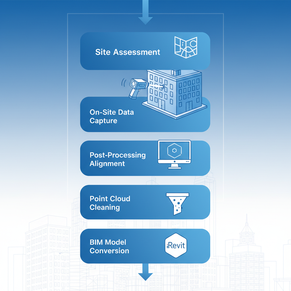
Illustrated 3D laser scanning workflow stages in NYC
Post-Processing and Point Cloud Alignment
Step 2 focuses on refining raw data through meticulous post-processing, where multiple scans from various angles are registered and aligned using specialized software. BuildScan3D’s experts clean datasets by removing noise from elements like moving pedestrians or temporary scaffolding, achieving sub-millimeter accuracy vital for New York City’s stringent building codes.
This involves automated algorithms to stitch point clouds, verifying overlaps to eliminate gaps, followed by manual checks for outliers. In urban datasets from sites like Brooklyn bridges, technicians adjust for environmental distortions, such as vibrations from subway lines. These NYC BIM processing techniques ensure comprehensive coverage, with processing timelines compressed to days rather than weeks, thanks to BuildScan3D’s optimized protocols.
Adaptations for New York include handling large-scale data from resorts in Staten Island, where alignment accounts for irregular terrains. This preparation stage bridges field collection and modeling, guaranteeing reliable inputs for design teams navigating the city’s fast-paced development cycle.
Conversion to BIM Models and Deliverables
Step 3 converts aligned point clouds into actionable BIM models, integrating scan to BIM in New York processes with tools like Autodesk Revit for seamless compatibility. BuildScan3D traces geometries to generate 3D models, 2D plans, and parametric elements such as HVAC systems or structural beams, automating where possible to enhance efficiency.
Detailed actions include layering data for clash detection and BOMA area calculations, producing outputs like virtual walkthroughs that allow clients to navigate digital twins remotely. For example, Revit files from Bronx infrastructure scans support renovation planning by overlaying existing conditions with proposed designs. This workflow answers queries on Revit modeling from 3D scans in New York, providing traceable elements for compliance reviews.
In New York projects, deliverables adapt to local needs, such as interactive tours for facility managers in Midtown offices. By delivering precise, Revit-ready files within tight schedules, BuildScan3D empowers AEC professionals to reduce rework and foster collaborative decision-making in the city’s dynamic built environment.
Best Practices for 3D Scanning and Scan-to-BIM in NYC
Implementing 3D scanning and scan-to-BIM processes in New York City’s fast-paced construction environment requires careful planning to achieve precision and efficiency. For architecture, engineering, and construction professionals, following established best practices ensures compliance with local regulations and seamless integration into project workflows. BuildScan3D, based in White Plains, exemplifies these standards with its comprehensive services across all boroughs.
Selecting Reliable Service Providers
Choosing NYC scanning experts is crucial for projects in dense urban areas like Manhattan. Start by evaluating certifications from organizations like the American Society of Photogrammetry and Remote Sensing, ensuring providers use advanced equipment such as Leica scanners for millimeter accuracy. Local experience matters, particularly for navigating New York City’s stringent building codes and tight site constraints.
- Equipment Quality: Opt for firms with Leica, Faro, or Navvis devices to capture detailed point clouds.
- Experience Level: Look for proven track records in similar NYC projects, such as landmark renovations.
- Certifications and References: Verify local licenses and client testimonials from borough-wide work.
The following table compares key factors for top scan-to-BIM providers in NYC, highlighting selection criteria based on industry standards from comprehensive guides on 3D laser scanning services.
| Provider | Equipment | Accuracy | NYC Coverage | Cost Range |
|---|---|---|---|---|
| BuildScan3D | Leica, Faro, Navvis | ±1mm | All boroughs | Project-based, scalable |
| Generic Provider A | Basic scanners | ±5mm | Limited | Higher fixed fees |
BuildScan3D stands out with its superior equipment and full borough coverage, offering scalable pricing that aligns with project needs. This local edge reduces delays in high-stakes environments, as supported by BIM integration articles emphasizing efficiency gains of up to 30% in urban modeling.
Cost Considerations and Project Planning
Budgeting for 3D laser scanning in NYC involves understanding variables like site size and complexity. Typical costs range from $0.50 to $2.00 per square foot for basic scans, with scan-to-BIM modeling add-ons at $1.50 to $5.00 per square foot, depending on detail levels. Urban challenges, such as accessing high-rise structures in Manhattan, can increase expenses by 20-30%.
- Scope Definition: Outline deliverables early, from point clouds to Revit files, to avoid scope creep.
- Timeline Alignment: Factor in NYC permitting timelines, aiming for 2-4 weeks for scanning and processing.
- Vendor Quotes: Contact BuildScan3D at +1 914 391 4631 or office@buildscan3d.com for customized estimates.
Implementation Tips for Optimal Results
Successful scan-to-BIM in New York demands thorough preparation to maximize data quality. Begin with site prep by clearing obstacles and ensuring safe access, especially in crowded boroughs like Brooklyn. Post-scan, verify data through alignment checks to achieve ±1mm precision, integrating results into workflows for clash detection and facility management.
- Data Verification: Use software like Autodesk ReCap to cross-check point clouds against as-built conditions.
- Integration Steps: Align scans with existing CAD models, incorporating NYC-specific elements like HVAC systems.
- Compliance Checks: Reference local regulations for ADA and fire safety in model development.
Advancing NYC Projects with BuildScan3D
In the dynamic world of architecture, engineering, and construction, 3D scanning in New York City stands out as a transformative tool, delivering unparalleled accuracy and efficiency for urban projects. This guide has explored how 3D laser scanning in NYC captures precise as-built data, enabling seamless scan to BIM in New York integration that minimizes errors and accelerates workflows. From reducing rework by up to 30% to enhancing coordination through digital twins, these technologies address key challenges in high-stakes environments like Manhattan high-rises or Brooklyn renovations. Best practices emphasize selecting certified providers who ensure millimeter-level precision, optimizing costs through streamlined processes compared to traditional surveying methods.
BuildScan3D emerges as the premier partner for these innovations, offering comprehensive coverage across all boroughs with state-of-the-art Leica, Faro, and NavVis equipment. Our team delivers tailored scan-to-BIM deliverables, virtual walkthroughs, and BOMA calculations, backed by glowing testimonials from NYC architects and contractors. Based in White Plains at 222 Bloomingdale Road, Suite 404, NY 10605, we provide local expertise that future-proofs projects against evolving regulations.
Ready to elevate your next venture? Contact BuildScan3D today for a free consultation–call +1 914 391 4631 or email office@buildscan3d.com. Request sample work to see our impact firsthand and unlock the future of NYC digital twins with local scanning innovations.
Embrace these advancements to turn ambitious visions into reality, fostering smarter, faster urban development.