3D Scanning For Architects Nyc
Table of Contents
3D Scanning for Architects in New York City
Navigating New York City’s dense urban landscape presents unique challenges for architects, from documenting historic brownstones to renovating towering high-rises under strict regulatory timelines. Traditional measurement methods often fall short in capturing intricate details efficiently. That’s where 3D scanning for architects in New York City transforms the process, offering precise, non-invasive data capture to streamline design and renovation projects (see 3d scanning new york city).
We specialize in 3D laser scanning services in New York City, utilizing certified Leica, Faro, and NavVis equipment to generate millimeter-accurate point clouds for as-built documentation. Our comprehensive offerings include scan to BIM in New York City, converting raw data into Revit-ready models, along with 3D virtual walkthroughs and BOMA calculations. In high-density environments like Manhattan and the boroughs, we address tight construction schedules and compliance needs with rapid on-site scanning–typically 4-8 hours–and processing turnaround in 3-5 business days. For instance, in the Pinnacle Penthouse project at the Woolworth Building, 3D laser scanning achieved ±1mm accuracy, saving significant time on historic structure analysis compared to manual methods.
This guide explores our scanning processes, key benefits for NYC projects, and best practices for selecting reliable partners. From point cloud to BIM conversion for New York projects to architectural laser scanning in NYC, discover how our White Plains-based team supports the tri-state area with expertise you can trust.
Fundamentals of 3D Laser Scanning and BIM in Architecture
What 3D Laser Scanning Entails for NYC Projects
3D laser scanning employs LiDAR technology to emit millions of laser pulses that reflect off surfaces, generating a dense 3D point cloud with ±1mm accuracy. This process captures spatial data in extraordinary detail, creating a digital replica of physical environments. We recommend this method for its precision using certified Leica, Faro, and NavVis equipment, which ensures reliable results for complex structures.
In the context of 3D scanning for architects in New York City, the technology excels at documenting existing conditions in high-density urban areas like Manhattan. It handles intricate architectural details, such as ornate facades on historic buildings, without disruption to ongoing operations. For 3d laser scanning services new york, providers deliver rapid on-site captures in 4-8 hours, tailored to tight borough timelines and regulatory demands.
The key takeaway is that 3D laser scanning minimizes errors in as-built documentation, empowering architects to integrate accurate data into design workflows seamlessly.
Key Differences Between 3D Scanning, Traditional Surveys, BIM, and 3D Modeling
3D laser scanning differs markedly from traditional surveys in its automated, non-contact approach versus manual measurements. Scanning achieves superior accuracy and speed, producing versatile outputs like point clouds for further processing. BIM, or Building Information Modeling, goes beyond basic 3D modeling by incorporating parametric data for collaboration, lifecycle management, and intelligent object relationships, while 3D modeling focuses solely on geometric representations without embedded attributes.
For architects navigating New York City’s challenges, such as renovating occupied high-rises or preserving landmarks, these distinctions are critical. Traditional methods often falter in dense settings due to access limitations and error risks, whereas scanning provides comprehensive data for coordination. In the Pinnacle Penthouse at the Woolworth Building case study, 3D scanning captured intricate details more efficiently than traditional techniques, enabling precise renovation planning without invasive disruptions.
To highlight these advantages:
- Accuracy and Speed: Scanning delivers ±1mm precision rapidly, outpacing labor-intensive tape measures.
- Output Versatility: Generates BIM-ready files, unlike 2D-only traditional deliverables.
- BIM vs. 3D Modeling: BIM enables clash detection and simulations; modeling lacks this interactivity.
New York City’s urban environment amplifies these differences, with narrow sites, historic protections, and multi-stakeholder projects demanding non-disruptive tools. High-rises and borough regulations require millimeter-level data to avoid costly rework, making scanning essential for compliance and efficiency.
| Aspect | 3D Laser Scanning | Traditional Survey Systems |
|---|---|---|
| Accuracy | ±1mm with Leica/Faro/NavVis scanners. Millimeter-level point clouds for detailed as-builts | Manual measurements with tape/total station. Typically ±5-10mm, prone to human error |
| Speed | 4-8 hours on-site capture. Rapid data collection for tight NYC timelines | Days to weeks for full site measurement. Labor-intensive, disruptive in occupied buildings |
| Output | Point clouds, BIM models, virtual tours. Revit-ready deliverables for design integration | 2D drawings only. Limited to plans/sections, no 3D visualization |
This comparison underscores how 3D laser scanning reduces project rework by 20-30% through precise data, saving time and costs in architectural endeavors across the tri-state area.
Interpreting these metrics, architects benefit from scanning’s ability to streamline workflows in fast-paced NYC projects. By providing BIM-ready outputs, it fosters better team coordination and minimizes on-site revisions. This efficiency translates to significant savings, particularly when addressing the complexities of existing conditions in urban renovations.
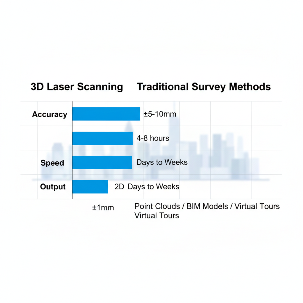
3D laser scanning vs traditional surveys: accuracy, speed, and output comparison
Scan-to-BIM Process Overview for Architectural Workflows
The scan-to-BIM process transforms raw laser scan data into intelligent models through structured steps. It begins with point cloud generation, followed by registration to align multiple scans accurately. Modeling then extracts architectural elements into Revit, with final validation ensuring BIM-ready accuracy at ±1mm.
For scan to BIM in New York City, this workflow supports compliance with local codes and enhances coordination among architects, engineers, and contractors on high-rise or renovation projects. We specialize in delivering these services for tri-state clients, using LiDAR surveying for NYC architecture to capture site-specific nuances like structural variances in older buildings.
Ultimately, the process equips teams with dynamic models that facilitate design iterations and reduce coordination errors, proving invaluable for urban architectural success.
Advantages of 3D Scanning Services for New York City Architects
At BuildScan3D, we deliver precise 3D scanning solutions tailored for architects navigating the dense urban landscape of New York City. Our services leverage advanced tools like Leica and Faro scanners to capture existing conditions with unparalleled detail, enabling seamless integration into Revit BIM models. This approach not only streamlines workflows but also ensures compliance with stringent local regulations, giving your firm a competitive edge in complex projects.
Enhanced Accuracy and Efficiency in Urban Projects
We achieve millimeter precision of ±1mm through building scanning services nyc, significantly reducing design errors in high-stakes urban environments. This accuracy supports as-built documentation and clash detection, allowing architects to identify discrepancies early and refine models before construction begins. By minimizing assumptions based on outdated drawings, our 3D laser scanning services in New York City eliminate costly revisions and enhance overall project reliability.
In Manhattan renovations, for instance, scanning historic brownstones captures intricate facades and internal structures without invasive measurements. This approach has helped firms avoid multiple site revisits, streamlining coordination with preservation boards and contractors amid tight timelines.
Key advantages include:
- Reduced error rates: Up to 90% fewer discrepancies in final designs.
- Faster site assessments: Complete data capture in 4-8 hours per location.
- Improved collaboration: Point cloud data shared instantly for team reviews.
These elements make 3D scanning for architects in New York City indispensable for precision-driven urban work, saving weeks in the planning phase.
Cost and Time Savings Through Scan-to-BIM Integration
Our scan-to-BIM in New York City processes transform raw point clouds into Revit-ready models within 3-5 business days, accelerating workflows compared to manual surveying. This integration facilitates BOMA calculations and clash detection, ensuring projects meet NYC building codes while optimizing budgets. By automating data conversion, we cut down on labor-intensive tasks, delivering measurable ROI from point cloud modeling in architecture.
For a Brooklyn high-rise development, our services enabled quick integration of existing utilities into BIM, identifying conflicts that prevented $50,000 in potential rework during permitting. Architects coordinated with engineers remotely, expediting approvals from the Department of Buildings.
Quantifiable impacts feature:
- Time efficiency: 40% faster workflows, as noted in ACM research on 3D modeling.
- Cost reductions: 20-30% savings on rework and delays.
- Compliance speed: Streamlined submissions for faster regulatory sign-off.
Embracing benefits of LiDAR for NYC designs through this method positions firms to handle volume without proportional expense increases.
Local Benefits for Tri-State Architectural Firms
We provide rapid response times across the boroughs, with our White Plains office ensuring coverage from Manhattan to the outer reaches of the tri-state area. This localized expertise means on-site assessments within hours, followed by virtual walkthroughs that enable remote collaboration for distributed teams. Our 3D virtual tours allow stakeholders to review progress without travel, ideal for coordinating large-scale projects in traffic-congested regions.
In a Queens institutional project, our team scanned a 100,000 sq ft facility overnight, producing walkthroughs that facilitated virtual meetings with out-of-state consultants. This avoided logistical hurdles, keeping the timeline on track despite borough-specific zoning challenges.
Notable local gains are:
- Borough-wide accessibility: Full coverage with minimal downtime.
- Remote enablement: Virtual tools reduce travel costs by 50%.
- Tri-state scalability: Seamless expansion beyond NYC borders.
These advantages underscore why adopting our scanning for tri-state initiatives boosts efficiency and fosters innovation in regional architecture.
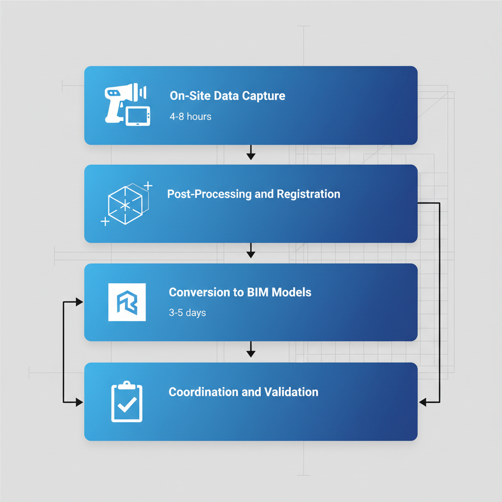
Step-by-Step Process of 3D Scanning and Scan-to-BIM in NYC
At BuildScan3D, we streamline the 3D scanning to BIM workflow for architects navigating the complexities of New York City’s dense urban landscape. Our process ensures precise existing conditions documentation with minimal disruption, delivering Revit-ready models that support efficient design and renovation projects. From initial assessment to final validation, we prioritize accuracy and speed tailored to tri-state demands.
On-Site Data Capture with Advanced Scanners
We begin 3D scanning for architects in New York City with a thorough site assessment to identify optimal scanner positions, ensuring comprehensive coverage of interiors and exteriors. Our team sets up certified equipment like Leica and Faro stationary scanners for high-detail areas, complemented by NavVis mobile systems for swift traversal in tight urban spaces. Scanning typically spans 4-8 hours, capturing millions of points non-invasively while adhering to safety protocols such as cordoning off active zones to protect ongoing operations.
- Pre-scan planning: Review blueprints and client needs for targeted data collection.
- Deployment: Position scanners strategically, often starting from building entrances.
- Capture: Generate point clouds at ±1mm accuracy, ideal for 3d scanning bronx sites with historical constraints.
This approach with 3D laser scanning services in New York City minimizes downtime in occupied Manhattan properties, allowing seamless integration into busy schedules.
Step-by-step 3D laser scanning and scan-to-BIM process in NYC
Post-Processing, Registration, and Point Cloud Refinement
Once data is captured, we transfer scans to our White Plains facility for post-processing, where alignment of multiple point clouds occurs using specialized software. This registration step overlays scans precisely, reducing overlaps and eliminating distortions from urban interferences like reflective glass. Noise reduction filters out artifacts, followed by rigorous quality checks to confirm ±1mm accuracy essential for tri-state architectural projects.
- Import and initial alignment: Merge datasets from various scanner positions.
- Cleaning: Remove extraneous points from temporary fixtures or debris.
- Validation: Cross-verify against control points for dimensional integrity.
Point cloud processing for architectural projects in New York City ensures clean, reliable data ready for modeling, cutting errors that plague manual methods.
Conversion to BIM Models and Deliverables
We convert refined point clouds into intelligent BIM models using Autodesk Revit, tracing structural elements, HVAC systems, and as-builts with parametric accuracy. Integration includes embedding metadata for clash detection and future updates, producing deliverables like interactive 3D models and virtual tours. Full scan to BIM in New York City timelines range from 3-5 days for processing to 2-4 weeks for comprehensive project delivery, aligning with regulatory deadlines.
- Tracing and modeling: Build layers from walls to MEP components.
- Enhancement: Add BIM families for HVAC and fixtures.
- Export: Generate Revit files, PDFs, and walkthrough videos.
In bustling NYC environments, this workflow for LiDAR to Revit in NYC accelerates design iterations without repeated site visits.
New York City sites often face constraints like limited access and high occupancy, making our efficient scan-to-BIM process invaluable for minimizing disruptions in boroughs from Brooklyn to the Bronx. We adapt to these challenges by leveraging mobile tools that require no scaffolding, ensuring data capture fits tight schedules while upholding safety standards.
| Stage | 3D Scanning Process | Traditional Method |
|---|---|---|
| Data Collection | Laser scanning (4-8 hours) Automated, non-contact capture | Manual measurements (days-weeks) Labor-heavy, site disruptions |
| Processing | Registration and modeling (3-5 days) Software-driven accuracy | Drafting by hand (weeks) Error-prone transcription |
| Deliverables | Revit BIM, virtual tours (2-4 weeks) Interactive, updatable files | Static 2D plans Limited revisions |
This comparison highlights how our 3D scanning process outperforms traditional surveys by reducing timelines by up to 70% and enhancing precision, which expedites architectural approvals in NYC’s stringent permitting landscape. Clients benefit from dynamic models that support ongoing revisions, fostering faster project progression without the pitfalls of outdated manual data.
Coordination and Final Validation for Architects
We facilitate client reviews through cloud-based platforms, incorporating feedback to refine models before clash detection scans for interferences in HVAC and structural elements. BOMA calculations are performed to meet NYC leasing standards, ensuring compliance with local codes. In the Pinnacle Penthouse at the Woolworth Building case study, our 6-hour scan yielded a detailed Revit model in three weeks, validating elevations and interiors for restoration.
- Review sessions: Share drafts for architect input.
- Clash resolution: Identify and adjust conflicts.
- Final sign-off: Deliver certified files with BOMA reports.
You build – we scan, providing BIM-ready assets that streamline coordination for New York City projects.
Selecting and Implementing 3D Scanning Providers in New York City
When it comes to 3D scanning for architects in New York City, selecting the right provider ensures precise data capture for your projects. We at BuildScan3D specialize in delivering millimeter-accurate point clouds using certified Leica and Faro equipment, tailored to the unique demands of urban architecture. Our rapid response times and coverage across the five boroughs make us a trusted partner for local professionals.
Criteria for Choosing Top 3D Laser Scanning Companies
Evaluating 3D laser scanning services in New York City starts with key factors that guarantee reliability and precision. First, prioritize providers with certifications in equipment like Leica and Faro scanners, ensuring ±1mm accuracy essential for architectural documentation. Local experience in navigating NYC’s dense environments is crucial, as is a proven turnaround of 3-5 days for processing.
Consider these actionable criteria in your selection process:
- Equipment Quality: Opt for firms using stationary and mobile scanners for comprehensive coverage.
- Local Expertise: Choose partners familiar with tri-state regulations and high-rise assessments.
- References and Pilots: Request case studies from similar NYC projects and conduct small-scale pilots.
By focusing on these, architects can select providers that align with project timelines and budgets, avoiding common pitfalls in urban scanning.
Understanding Costs and Project Scoping for NYC Architects
Costs for scan to BIM in New York City vary based on site size, complexity, and deliverables. Pricing often follows a per-square-foot model, starting at competitive rates for basic point cloud generation, with add-ons for Revit-ready models or virtual walkthroughs. Factors like accessibility in Manhattan high-rises or multi-level structures in the boroughs can influence final quotes.
To budget effectively for BIM services in Manhattan, outline your scope early:
- Site Assessment: Factor in 4-8 hours of on-site scanning time.
- Complexity Adjustments: Add premiums for intricate details or post-processing needs.
- Delivery Options: Standard 3-5 day turnaround keeps costs lower than expedited services.
We guide clients through scoping to optimize expenses while maintaining BIM-ready outputs for seamless integration into design workflows.
Tips for Effective Collaboration and Project Management
Effective collaboration begins with pre-scan planning, where we coordinate site preparation and access logistics for Manhattan and borough projects. Clear communication on data requirements ensures alignment, from initial capture to validation of point clouds and models. Drawing on insights from digital libraries like the ACM’s work on interactive 3D environments, we emphasize workflows that enhance architect-provider interactions through real-time reviews.
Implement these steps for smooth management:
- Pre-Scan Coordination: Schedule assessments to minimize disruptions.
- Data Validation: Review registered scans jointly for accuracy.
- Final Reviews: Use virtual walkthroughs to confirm deliverables.
Our approach fosters trust and efficiency, delivering projects on time across the tri-state area.
Local Considerations for Bronx, Manhattan, and Beyond
In the Bronx, challenges like industrial site access require providers with flexible scheduling, while Manhattan’s high-rises demand 3d laser scanning manhattan expertise for vertical navigation. We cover all boroughs and beyond, ensuring seamless service without jurisdictional hurdles. Our White Plains base enables rapid deployment, addressing urban density and permitting variations effectively.
Elevating Architectural Projects with 3D Scanning in New York City
In the dynamic landscape of architecture, 3D scanning for architects in New York City stands out as a transformative tool, delivering unmatched precision and efficiency for complex urban projects. By recapping the core advantages, we’ve seen how our 3d modeling new york services enhance accuracy to ±1mm levels and accelerate workflows from data capture to final deliverables. The seamless process, powered by Leica equipment, ensures rapid on-site scanning and reliable scan to BIM in New York City, minimizing errors and supporting optimized BIM workflows for New York developments.
Key takeaways reinforce the value of selecting experienced providers who offer 3D laser scanning services in New York City, with best practices focusing on cost-effective management through our tri-state coverage. As digital libraries and interactive 3D environments evolve, per insights from ACM publications, the future of architectural scanning in NYC promises even greater integration for innovative designs. Our virtual tours and Revit-ready models provide the edge needed for successful implementations.
We invite you to elevate your next project with our White Plains-based expertise. You build – we scan. Book a consultation today to discuss how our scan to BIM solutions can meet your NYC architectural needs across the tri-state region.
