Building 3D Laser Scanning Services
Table of Contents
Unlocking Precision with Building 3D Laser Scanning Services
In the fast-paced world of modern construction and infrastructure, building 3D laser scanning services have emerged as a game-changer. This reality-capture technology harnesses LiDAR to create millimeter-accurate point clouds, transforming physical sites into precise digital twins. Based in White Plains, New York, BuildScan3D leads the charge with its innovative hybrid mobile-static scanning approach, delivering essential data for architects, contractors, and facility managers across New York and beyond. According to the 2025 industry standards, these scans achieve exceptional accuracy while maintaining quick turnaround times, often within days for complex projects.
At its core, 3D laser scanning construction captures every detail of a site, from structural elements to MEP systems, enabling applications like clash detection and progress monitoring. BuildScan3D employs NavVis mobile scanners for rapid coverage in schedule-sensitive environments and Leica or Faro static units for high-precision work. Key deliverables include raw point clouds, Revit models through scan to BIM services, and interactive virtual walkthroughs that streamline coordination and reduce costly rework. This precise site scanning for buildings ensures seamless integration into BIM workflows, addressing common pain points in commercial projects.
Discover how LiDAR-based construction capture can accelerate your timelines and minimize errors. BuildScan3D, headquartered at 222 Bloomingdale Road, Suite 404, White Plains, NY 10605, invites you to request a quote today at (914) 468-4400. Upcoming sections delve deeper into fundamentals, helping you unlock the full potential of these services for your next project.
Essentials of 3D Laser Scanning Technology
At the heart of modern construction workflows lies 3D laser scanning technology, a precise method that transforms physical spaces into detailed digital representations. Building 3D laser scanning services capture the exact geometry of structures using laser pulses, enabling architects and contractors to visualize and analyze sites with unprecedented clarity. This technology, often likened to a digital measuring tape that records millions of points per second, revolutionizes site reality capture by providing accurate data for planning and execution.
The process begins with laser emitters sending out rapid pulses of light toward a surface. These pulses reflect back to sensors, which calculate distances based on the time of flight, creating a dense array of spatial coordinates. In seconds, scanners generate over a million points, forming the foundation for comprehensive 3D models. This step-by-step mechanism answers how 3D laser scanning works, ensuring every element from walls to fixtures is documented faithfully.
Hardware forms the backbone of effective 3D laser scanning. Key devices include mobile LiDAR units, which allow technicians to scan while walking through sites, and static terrestrial scanners that mount on tripods for stationary, high-detail captures. Popular examples encompass NavVis mobile scanners, ideal for rapid surveys in dynamic environments, and Leica static units, renowned for their pinpoint precision in controlled settings.
- NavVis VLX: Portable backpack systems for hands-free operation on large construction floors.
- Leica BLK360: Compact terrestrial scanners delivering full-dome views with integrated cameras.
- Faro Focus: Versatile options supporting both indoor and outdoor LiDAR surveying for structures.
These tools, drawn from industry-standard workflows, enable flexible data collection tailored to project demands.
Selecting the right scanning method depends on project scale, timeline, and required detail. For instance, mobile systems excel in expansive areas, while static setups prioritize intricate measurements. The following table outlines key differences among common approaches, based on 2025 industry benchmarks for typical construction-grade scans with accuracies ranging from ±1-5mm.
| Method | Speed | Accuracy | Best For |
|---|---|---|---|
| Mobile LiDAR | High (covers large areas quickly) | ±5-10mm | Schedule-sensitive sites |
| Static Terrestrial | Medium (detailed setup required) | ±1mm | Precision interiors and facades |
| Drone-Based | Very High (aerial coverage) | ±20mm | Exterior building envelopes |
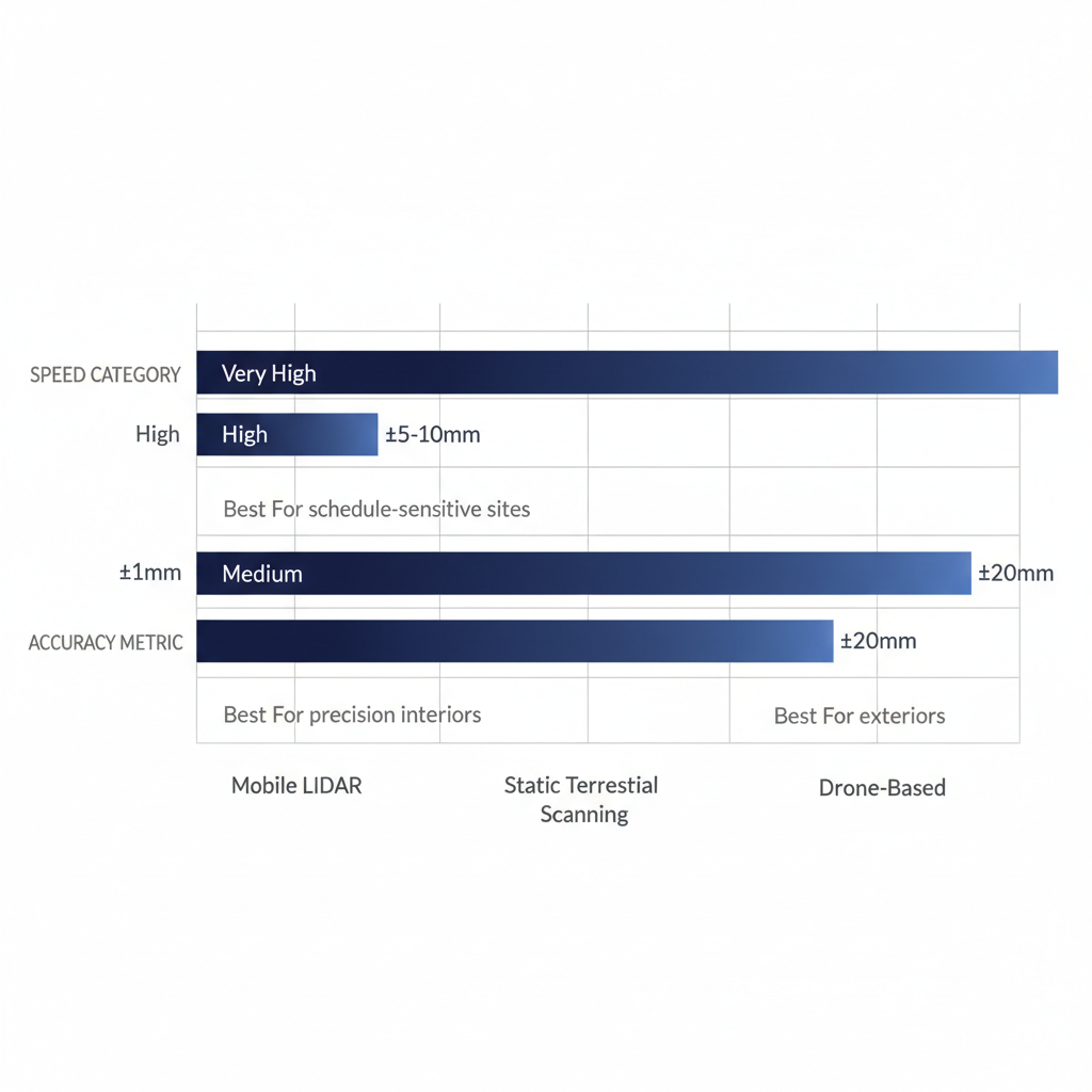
Comparison of 3D laser scanning methods for speed and accuracy in construction
BuildScan3D leverages a hybrid approach, combining mobile LiDAR for swift coverage with static terrestrial scanning for refined accuracy. This strategy optimizes results, reducing fieldwork time by up to 50% while maintaining design-grade precision, as validated by leading practices in 3D laser scanning construction.
Accuracy stands as a cornerstone of reliable data output. Advanced scanners achieve resolutions up to ±1mm, crucial for design-grade work where even minor discrepancies can impact structural integrity. The resulting point cloud–a vast dataset of 3D coordinates–serves as raw material for software processing into meshes, BIM models, or virtual walkthroughs. BuildScan3D’s deliverables, for example, provide this millimeter-level fidelity, minimizing errors in renovations or expansions and supporting seamless integration with tools like Revit.
Turning to applications, 3D laser scanning construction enhances site surveys by producing as-built documentation that verifies compliance and facilitates clash detection. In practice, it supports MEP coordination, progress monitoring, and facility management, ensuring projects in areas like White Plains, New York, proceed efficiently. Whether documenting existing conditions or planning retrofits, this technology delivers actionable insights. For a tailored demo of these essentials, contact BuildScan3D to explore how their precision services can elevate your next project.
Exploring 3D Laser Scanning in Construction
In the dynamic world of construction, 3D laser scanning transforms how professionals capture and utilize site data. This technology provides detailed digital representations that support every project phase, from initial planning to final handover. For contractors and owners seeking precision, building 3D laser scanning services offer a competitive edge by minimizing discrepancies and accelerating timelines.
Applications and Benefits for Project Sites
3D laser scanning finds versatile applications across construction phases, enhancing efficiency at each step. In the pre-design stage, teams use it for site documentation to create accurate topographic models, allowing architects to plan layouts with confidence. During design and pre-construction, precision scanning for builds aids in MEP coordination, ensuring systems like plumbing and electrical integrate seamlessly without conflicts.
As projects move to construction, 3D laser scanning construction supports progress tracking by generating point clouds that verify installations against plans. For instance, in commercial developments in New York, such as office towers in White Plains, scanning captures existing conditions for renovations, reducing surprises during demolition. At handover, as-built verification confirms that the final structure matches digital models, speeding up approvals and occupancy.
The benefits extend to reduced errors through high-fidelity data, fostering better collaboration among stakeholders. Contractors report faster decision-making with virtual walkthroughs, which enable remote reviews without site visits. In one New York hospital project, scanning cut coordination time by 20 percent, avoiding costly rework. Overall, these applications streamline workflows, making projects more predictable and profitable.
Traditional surveying methods often fall short in complex environments, relying on manual measurements that introduce human error and limit detail. These approaches struggle with intricate sites, leading to incomplete data and delays in verification.
| Aspect | 3D Laser Scanning | Traditional Surveying |
|---|---|---|
| Accuracy | ±1mm | ±10-50mm |
| Time Efficiency | Days for large sites | Weeks |
| Cost Savings | Reduces rework by 20-30% | Higher error rates |
This comparison highlights how 3D laser scanning outperforms legacy techniques, delivering millimeter-level precision that BuildScan3D achieves through its hybrid mobile and static scanning methods. By integrating construction site LiDAR capture, firms like BuildScan3D minimize discrepancies, saving time and resources on projects in the New York area. These advantages translate to tangible gains, such as lower overall costs and smoother handovers for commercial sites.
Improving Workflows with Precise Data Capture
Integrating 3D laser scanning into construction management revolutionizes daily operations, starting with clash detection. Scanned point clouds overlay with BIM models to identify interferences early, preventing expensive field adjustments. For example, in a White Plains, New York high-rise, BuildScan3D’s deliverables revealed HVAC conflicts before installation, saving weeks of labor.
Progress tracking becomes effortless with time-series scans that document site evolution. BuildScan3D employs NavVis mobile scanners for rapid captures on schedule-sensitive jobs and Leica static units for detailed precision, producing aligned datasets for real-time monitoring. This approach supports remote access via online virtual walkthroughs, allowing architects and owners to review advancements without travel, ideal for institutional projects like campuses in New York.
Beyond detection, these tools enhance collaboration by delivering Revit models and 2D plans directly usable in design software. Facility managers benefit from BOMA-compliant area calculations and floor flatness analysis, ensuring compliance for post-construction use. In one infrastructure upgrade near New York City, precision scanning for builds reduced fabrication errors by integrating scanned data into workflows, cutting material waste.
BuildScan3D’s New York-focused services emphasize hybrid scanning to balance speed and accuracy, tailoring outputs like scan-to-BIM for MEP coordination. This integration addresses common challenges, such as aligning as-builts with plans, by providing cloud-hosted visualizations for team input. Quantitatively, industry reports note error reductions up to 30 percent, aligning with virtual walkthroughs that enable proactive monitoring as described in laser scanning applications.
To leverage these improvements, contractors can schedule scans tailored to their timelines. Whether for clash detection in dense urban sites or progress tracking on bridges, BuildScan3D’s deliverables empower teams to maintain momentum. By adopting 3D laser scanning construction techniques, projects in White Plains and beyond achieve greater efficiency, fewer disruptions, and enhanced stakeholder satisfaction. Consider reaching out to discuss how these services fit your next build.
Implementing Scan-to-BIM in Building Projects
Implementing scan to BIM services transforms raw laser scan data into intelligent 3D models that drive project efficiency. For construction professionals seeking precise digital representations, this approach integrates seamlessly with workflows, particularly when using specialized providers like BuildScan3D. By converting point clouds into actionable BIM elements, teams can enhance coordination and reduce errors from the outset.
Step-by-Step Scan-to-BIM Process
The scan-to-BIM process begins with meticulous planning to ensure accurate data capture tailored to project needs. Start by conducting a site assessment to identify key areas, such as structural elements and MEP systems in existing buildings. This initial step involves coordinating with stakeholders to define scan resolutions, often aiming for millimeter-level precision as offered in building 3D laser scanning services. Using tools like stationary terrestrial scanners or mobile LiDAR, teams capture comprehensive point clouds on-site, minimizing disruptions while covering large areas efficiently.
Next, transfer the raw data to processing software for cleaning and registration. This phase aligns multiple scans into a unified point cloud, removing noise and outliers to create a reliable dataset. For instance, BuildScan3D employs hybrid scanning methods with Leica and Faro devices to achieve ±1mm accuracy, ideal for renovation projects in New York. The cleaned point cloud then undergoes modeling, where points are converted into Revit-compatible elements like walls, floors, and ducts. Skilled modelers trace geometries, embedding parametric data for clash detection and simulations.
Once the model is drafted, perform quality checks and validations against as-built conditions. Iterate as needed to refine details, ensuring the output supports downstream applications like facility management. Finally, export the BIM model in formats such as IFC or RVT, ready for integration into design software. BuildScan3D’s consulting support streamlines this workflow, delivering BIM-ready scanning outputs within tight timelines. Throughout, emphasize best practices from industry guidelines, such as phased scanning to control costs–typically $0.25 to $0.50 per square foot for processing, according to scanning cost analyses. This structured approach addresses how scan to BIM works for building models, making it accessible for teams handling renovations or expansions.

Five-step vertical scan-to-BIM process flow for construction projects
Selecting the right software is crucial for efficient point cloud to model conversion in 3D laser scanning construction. Factors like integration with existing tools, accuracy thresholds, and user interface play key roles in choosing options that align with project demands.
| Software | Key Features | Accuracy | Ease of Use |
|---|---|---|---|
| Revit (Autodesk) | Native BIM modeling, MEP tools | ±1mm import | High (integrated workflow) |
| Bentley ContextCapture | Reality mesh generation | ±2mm | Medium (specialized) |
| Leica Cyclone | Point cloud registration | ±1mm | Advanced (professional) |
BuildScan3D focuses on Revit-compatible outputs, leveraging its native BIM capabilities for seamless MEP integration and high accuracy. This choice accelerates workflows for transactional users, reducing the learning curve while maintaining professional-grade results. Vendor specifications highlight Revit’s edge in collaborative environments, making it a go-to for scan to BIM services in complex builds.
Advantages for Architecture and Coordination
Scan to BIM services offer transformative benefits for architecture, enabling precise design revisions based on real-world conditions. In renovation projects, accurate point cloud data prevents costly rework by visualizing existing structures down to the millimeter. For example, a New York hospital expansion utilized BuildScan3D’s outputs to overlay new designs on scanned interiors, identifying spatial conflicts early and saving weeks in planning.
- Enhanced MEP Integration: BIM-ready scanning outputs facilitate clash-free coordination between mechanical, electrical, and plumbing systems. Traditional manual measurements often miss hidden interferences, but scan to BIM services import precise geometries into Revit, allowing automated detection. This reduces on-site errors by up to 30%, as seen in commercial retrofits where ductwork alignments were optimized pre-installation.
- Improved Facility Management: Post-construction, these models serve as digital twins for ongoing operations. Facility managers access interactive 3D views for maintenance scheduling, with embedded data on asset locations. In a White Plains office tower case, BuildScan3D’s deliverables supported BOMA-compliant area calculations, streamlining space allocation and compliance reporting.
- Cost and Time Savings: By minimizing field verifications, point cloud to model conversion cuts project timelines significantly. Cost analyses indicate that integrating scan to BIM services can lower overall expenses by 15-20%, factoring in reduced change orders. For existing buildings, this means faster permitting and stakeholder approvals, with actionable insights from virtual walkthroughs.
- Collaborative Design Advantages: Architects benefit from immersive reviews, fostering better team decisions. In 3D laser scanning construction, shared BIM files enable remote consultations, crucial for distributed teams. BuildScan3D’s online virtual tours, derived from scans, enhance this by providing time-series progress monitoring without travel.
These advantages underscore why scan to BIM services are essential for modern architecture and coordination. To start your scan-to-BIM project with BuildScan3D, contact their White Plains headquarters for a tailored quote, leveraging their expertise in New York-area initiatives.
Advanced Applications and Considerations for 3D Scanning
Advanced applications of 3D laser scanning extend beyond basic site documentation, enabling high-precision infrastructure scanning for complex structures like bridges and expansive campuses. In 3D laser scanning construction projects, professionals capture intricate details of aging infrastructure to support renovation and expansion efforts. For instance, scanning bridges allows engineers to assess structural integrity without invasive methods, while campus scans facilitate space optimization and facility upgrades. BuildScan3D employs a hybrid approach, combining mobile LiDAR for rapid coverage and static terrestrial scanners like Leica and Faro for millimeter accuracy, delivering actionable data that reduces rework and accelerates coordination.
Cost structures in advanced building 3D laser scanning services vary based on project complexity, deliverable type, and site conditions. Factors such as scan density, environmental challenges, and post-processing demands influence pricing, with estimates for 2025 reflecting rising demand for detailed outputs. Per square foot costs provide a clear budgeting framework, helping stakeholders plan for sophisticated needs. The following table breaks down pricing for common deliverables:
| Deliverable | Cost per Sq Ft | Typical Project Size |
|---|---|---|
| Point Cloud Only | $0.50-$1.00 | Up to 50,000 sq ft |
| Scan-to-BIM Model | $2.00-$5.00 | 10,000-100,000 sq ft |
| Virtual Walkthrough | $1.50-$3.00 | All sizes |
These ranges, drawn from industry benchmarks, highlight the value in scan to BIM services for integrated modeling. For tailored quotes, especially in New York projects, contacting BuildScan3D ensures competitive pricing aligned with specific requirements.
Evaluating top 3D laser scanning companies in the US emphasizes accuracy, service range, and innovation. BuildScan3D stands out with its New York headquarters in White Plains, offering nationwide reach but specialized focus on regional needs. The firm excels in BOMA calculations and floor analysis, providing Revit models, 2D floorplans, and clash detection for construction workflows. Key considerations include:
- Accuracy Levels: ±1mm precision for design-critical tasks.
- Software Integration: Advanced tools for point cloud processing into BIM deliverables.
- Custom Support: Hybrid scanning and consulting to address unique challenges like HVAC coordination.
This positions BuildScan3D as a leader for users seeking reliable scan to BIM services, prompting inquiries for advanced project support.
Frequently Asked Questions on 3D Laser Scanning
Building 3D laser scanning services often raise common queries about costs, benefits, and processes for construction projects. Here are answers to help you get started with BuildScan3D.
Q: What is the cost of 3D laser scanning services for construction?
A: Costs vary by project size and complexity, typically ranging from $0.25 to $1.00 per square foot. Contact BuildScan3D for a personalized quote tailored to your needs.
Q: What are the benefits of 3D laser scanning for building sites?
A: It provides precise digital models that reduce onsite errors, speed up coordination, and enhance safety in 3D laser scanning construction workflows.
Q: How does 3D laser scanning improve construction projects?
A: By capturing accurate site data, it supports clash detection and efficient planning through scan to BIM services, minimizing rework and delays.
Q: What is the accuracy level of these scans?
A: BuildScan3D delivers millimeter-accurate results, up to ±1mm, ensuring reliable data for design and facility management.
Q: How can I start with laser scan FAQs for builds?
A: Schedule a consultation with BuildScan3D to discuss your project and receive expert guidance on implementation.
Elevate Your Projects with Precision Scanning
Embrace the transformative power of building 3D laser scanning services to revolutionize your construction workflows. At BuildScan3D, our expertise in 3D laser scanning construction delivers unparalleled ±1mm accuracy, blending hybrid mobile and static scanning for efficient, precision building capture. From scan to BIM services that streamline design and reduce errors, to cost-effective outcomes highlighted in recent guides–saving up to 20% on rework–these tools ensure superior project results.
Ready to elevate your next endeavor? Contact BuildScan3D today for a personalized quote. Reach our White Plains headquarters at 222 Bloomingdale Road, Suite 404, White Plains, NY 10605, or call (914) 555-0123 to discuss how our services can propel your projects forward with unmatched precision and ease.
