3D Scanning Long Island
Table of Contents
Discovering 3D Scanning Services in Long Island
Long Island’s construction and renovation boom demands precise documentation for complex projects, making 3D scanning in Long Island an indispensable tool for architects, engineers, and contractors. This technology captures existing structures with millimeter accuracy, supporting seamless design and coordination in the region’s dynamic building landscape.
At its core, 3D scanning employs laser scanners such as Leica and Faro to generate detailed point clouds, which form the basis for BIM models. Key applications include reverse engineering and assessing existing conditions, helping teams identify clashes early and reduce costly rework. Benefits extend to improved project timelines and enhanced collaboration, particularly for coastal infrastructure like bridge renovations in Nassau County.
BuildScan3D stands out as a trusted provider of laser scanning in Long Island, utilizing both stationary and mobile scanners for high-precision 3D capture on Long Island. With ±1mm accuracy, their scan to BIM in Long Island services deliver actionable data for facility management and design workflows across the area.
Explore how these laser-based modeling services in the region can address your project’s unique challenges; schedule a consultation to scope tailored solutions.
Overview of 3D Scanning in the Long Island Area
3D scanning in Long Island has become essential for capturing precise existing conditions in architecture, engineering, and construction projects. The region’s mix of urban density, suburban sprawl, and coastal landscapes presents unique challenges, such as historic renovations in Nassau County and infrastructure assessments along Suffolk’s shores. Local firms like BuildScan3D utilize advanced laser technology to document buildings, bridges, and resorts with millimeter accuracy, supporting everything from BIM modeling to clash detection.
Long Island’s diverse geography spans bustling urban centers in Brooklyn and Queens to rural coastal areas in Suffolk County and suburban sites in Nassau. This variation influences how 3D scanning services are deployed, with providers adapting equipment for tight interiors or expansive exteriors. For instance, coastal erosion risks demand detailed scans for flood-prone structures, while historic sites require non-invasive documentation to preserve integrity.
The following table compares key service areas within Long Island for 3D scanning, highlighting coverage, typical project types, and accuracy levels to help clients select based on location needs.
| Sub-Region | Coverage Focus | Common Projects | Accuracy Level |
|---|---|---|---|
| Nassau County | Urban and suburban sites | Commercial buildings, residential renovations | ±1mm (High-density scanning for interiors, ideal for precise BIM modeling) |
| Suffolk County | Coastal and rural areas | Bridges, resorts, infrastructure | ±1-2mm (Mobile scanning for large exteriors, suited for reverse engineering) |
| Brooklyn/Queens | Dense urban environments | HVAC modeling, clash detection | ±1mm (Stationary scanners for tight spaces, supports facility management) |
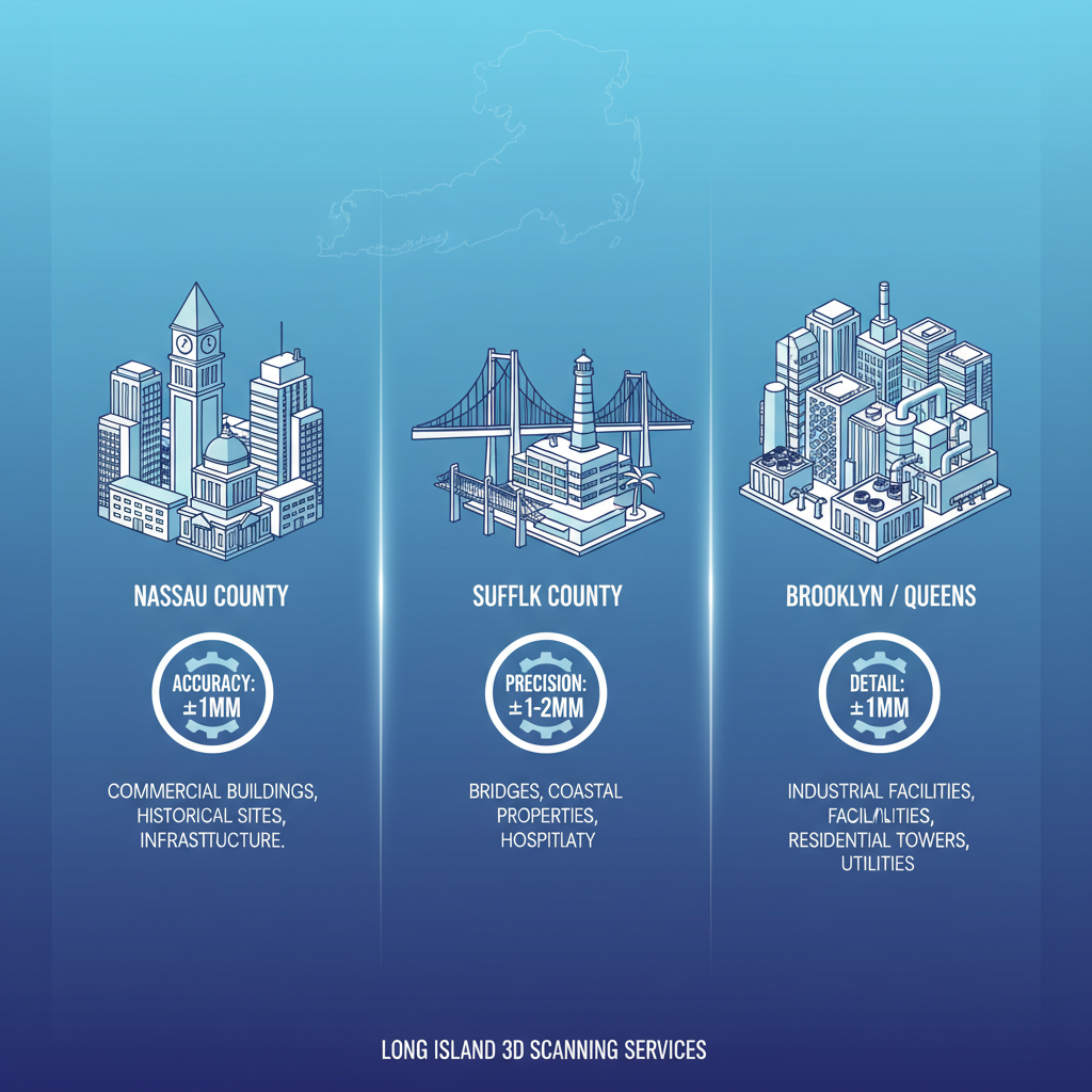
Comparison of 3D scanning service areas and precision in Long Island regions
This comparison illustrates how Nassau’s high-precision scans suit interior-focused renovations, while Suffolk’s mobile options handle larger coastal projects. Clients in Brooklyn and Queens benefit from stationary setups in crowded spaces. For tailored advice, consultations with experts can align these capabilities to specific sub-area needs, such as pipeline networks or resort expansions.
Laser scanning in Long Island employs Leica and Faro scanners to generate detailed point clouds, enabling virtual walkthroughs and floor flatness analysis. These tools capture data efficiently, even in challenging environments like flood-prone sites.
The scan reduced our rework by 30% through accurate as-built documentation.
In local applications, scan to BIM in Long Island streamlines workflows by converting point clouds into Revit models for construction progress monitoring. This integration supports architectural surveys and asset inventories, minimizing errors in regional builds. Benefits include cost savings and enhanced coordination, paving the way for accessible service options across the area.
Service Availability for 3D Laser Scanning in Long Island
In Long Island, professionals in architecture, engineering, and construction can access comprehensive 3D scanning services tailored to regional projects. These offerings support precise documentation for HVAC assessments, asset inventories, and facility upgrades.
- Point cloud delivery in standard formats for immediate analysis.
- 2D and 3D floor plans generated from captured data.
- Revit BIM files compatible with popular design software like Autodesk and Bentley systems.
- Virtual walkthroughs providing immersive project reviews.
The scan-to-BIM process in Long Island begins with on-site data capture using certified equipment, followed by post-processing alignment and model creation. Field teams employ stationary and mobile scanners to ensure millimeter-level accuracy, then register point clouds into cohesive models. This workflow integrates seamlessly with facility management systems, enabling long-term asset tracking.
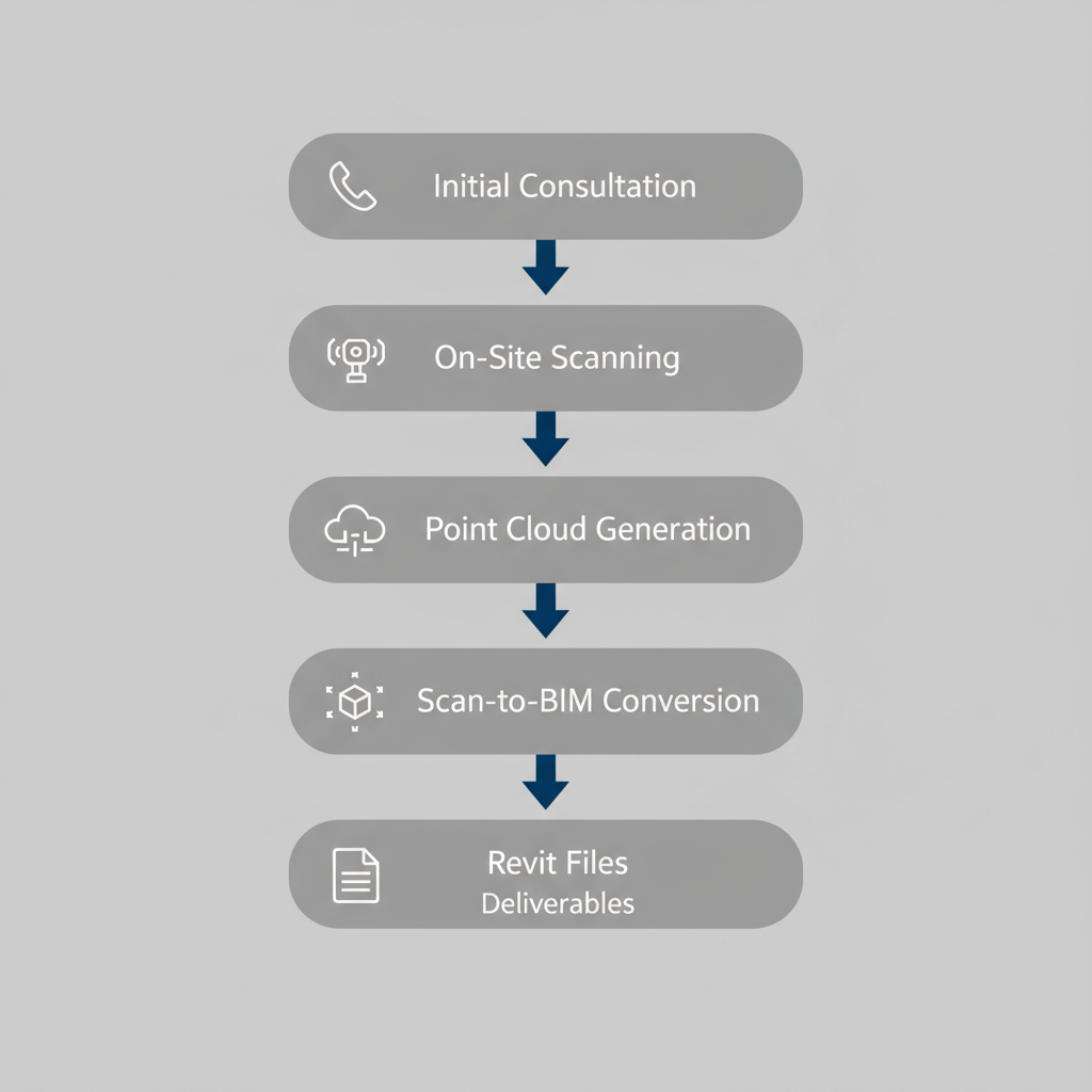
3D laser scanning service process in Long Island
Response times typically range from 24-48 hours for initial consultations, with scheduling flexible to accommodate tight construction timelines. Local BIM modeling from scans ensures deliverables align with Long Island’s regulatory and project-specific needs, facilitating efficient decision-making for contractors and managers.
Local Considerations for 3D Scanning Projects in Long Island
When planning 3D scanning projects in Long Island, local factors like costs, accuracy needs, and environmental influences play a crucial role in successful outcomes for construction and facility management. These considerations help businesses in coastal and urban areas achieve precise documentation for reverse engineering, inspections, and more.
Costs for 3D scanning in Long Island vary based on several key elements. Project size, scanner type, and post-processing demands drive expenses, with architectural surveys typically ranging from $5,000 to $20,000 according to industry benchmarks. For instance, higher scan density for detailed captures increases pricing, as noted in budgeting guides for regional projects. Businesses can explore cost-effective scanning solutions in Long Island by prioritizing essential deliverables to optimize budgets.
Accuracy directly affects deliverables like BIM models, where scan to BIM in Long Island ensures millimeter-level precision for clash detection and design integration. Benefits of laser scanning in Long Island include significant time savings, reducing rework by up to 30% in facility updates, and providing precise local modeling benefits that enhance coordination with existing systems.
Environmental challenges, such as coastal weather, can complicate outdoor scans, requiring protected scheduling to maintain data quality. Regulatory considerations for New York infrastructure, like strict building codes for historic sites, demand compliant documentation to avoid delays.
Getting Started with 3D Scanning in Long Island
Embark on your 3D scanning projects in Long Island by reaching out for an initial consultation. Contact BuildScan3D via phone at +1 914 391 4631 or email at office@buildscan3d.com to discuss your needs. This step involves a brief overview of your project goals, followed by scheduling a site assessment to evaluate the space and identify scanning requirements.
Next, scoping defines the project’s boundaries through a detailed site visit in Long Island. Gather specifics on areas to scan, such as HVAC systems or structural elements, using laser scanning in Long Island techniques for precision. Requirements include data formats like point clouds or Revit models, with timelines typically spanning 1-2 weeks from capture to deliverables, based on New York project examples.
In reverse engineering applications, 3D scanning captures legacy components for modernization, such as modeling outdated HVAC in existing facilities. This process supports scan to BIM in Long Island, converting point clouds into accurate BIM models with ±1mm precision to answer queries on usage, conversion methods, and accuracy levels for local projects.
Elevating Projects with 3D Scanning in Long Island
Embrace the transformative power of 3D scanning in Long Island to revolutionize your architectural and engineering projects. From enhanced accuracy in design to streamlined construction workflows, these services deliver local precision modeling that minimizes errors and boosts efficiency. Applications like reverse engineering and scan to BIM in Long Island ensure seamless integration, while laser scanning in Long Island reduces rework and costs significantly.
As highlighted in resources on 3D Scanning Services in Long Island, such technologies offer streamlined workflows for superior project outcomes. Discover how BuildScan3D, based at 222 Bloomingdale Road, Suite 404, White Plains, NY 10605, can elevate your work.
Ready to transform your vision? Contact us today at +1 914 391 4631 or office@buildscan3d.com for a consultation and request sample work to explore tailored solutions for your Long Island initiatives.
