3D Building Scanning Services
Table of Contents
Unlocking Precision with 3D Building Scanning Services in New York
In the fast-paced construction landscape of New York, where urban density demands unparalleled accuracy, 3D building scanning services in New York have become essential for architects, contractors, and facility managers. BuildScan3D, headquartered in White Plains, leads this innovation by capturing intricate details of structures like Manhattan high-rises. These services transform physical sites into digital assets, streamlining project coordination and reducing costly errors from the outset.
At its core, 3D laser scanning services involve using LiDAR and terrestrial scanners to generate detailed point clouds, representing buildings with millimeter precision–often achieving ±1mm accuracy for design workflows. This laser-based building capture in NYC enables comprehensive site documentation without disruptions. Complementing this, scan to BIM services convert raw scan data into intelligent Building Information Models, such as Revit files, facilitating seamless integration into construction and facility management processes. BuildScan3D employs a hybrid approach, blending mobile NavVis platforms for rapid scans on time-sensitive projects with static Leica and Faro scanners for high-precision needs. Key deliverables include point clouds, virtual walkthroughs, and BOMA area calculations, supporting everything from clash detection to space planning.
This guide explores the fundamentals of these technologies, step-by-step processes, and real-world applications tailored to New York projects. Whether you’re renovating a commercial space or managing infrastructure, BuildScan3D’s expertise ensures efficient, actionable results. Contact their team today to discuss how these services can elevate your next venture in the NYC area.
Core Principles of 3D Laser Scanning
In the fast-paced world of New York construction, 3d building scanning services in New York have become essential for capturing precise site data efficiently. 3D laser scanning services rely on advanced LiDAR technology to create detailed digital representations of physical structures, enabling architects and contractors to visualize and plan with unprecedented accuracy. This section explores the core principles behind this technology, highlighting how BuildScan3D leverages it for superior project outcomes in urban environments.
At its heart, 3D laser scanning operates on the principles of light detection and ranging, or LiDAR. A laser scanner emits millions of infrared light pulses toward a surface, measuring the time it takes for each pulse to reflect back. This process generates a point cloud, a dense collection of 3D coordinates that map out the exact geometry of buildings, interiors, and exteriors. Think of it as digital photography in 3D, where instead of capturing light on a sensor, the scanner records distances to build a virtual model. For commercial and institutional projects in New York, this foundational mechanic ensures comprehensive documentation, from high-rise facades to intricate MEP systems. BuildScan3D employs this technology to deliver millimeter-level precision, supporting seamless integration into design workflows.
BuildScan3D utilizes both mobile and static scanners to optimize data collection based on project needs. Static terrestrial scanners, such as Leica and Faro models, provide stationary, high-resolution captures ideal for detailed interior scans in controlled environments like office buildings. In contrast, mobile LiDAR platforms like NavVis enable rapid on-site scanning for larger sites, such as New York campuses or bridges, covering extensive areas in hours without disrupting operations. This hybrid approach allows flexibility, ensuring precise building LiDAR capture even in dense urban settings where time and access are limited.
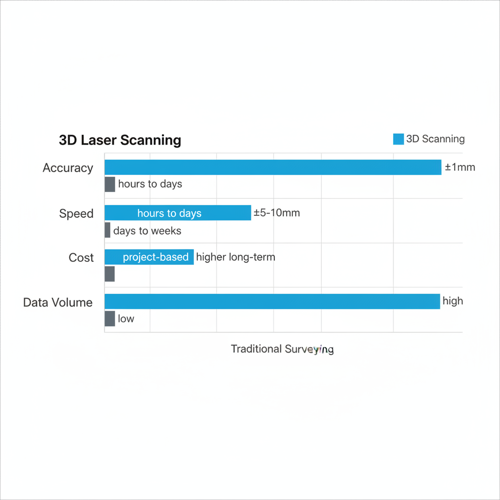
For New York construction projects, comparing 3D laser scanning to traditional surveying methods reveals significant advantages in efficiency and reliability, especially amid tight schedules and high stakes. Urban developers often face challenges like limited site access and error-prone manual measurements, making modern tools crucial for minimizing delays and costs.
| Aspect | 3D Laser Scanning | Traditional Surveying |
|---|---|---|
| Accuracy | ±1mm for detailed building scans | ±5-10mm, manual measurements prone to error |
| Speed | Hours to days for full site capture | Days to weeks, labor-intensive |
| Cost | Project-based, scalable for complexity | Higher long-term due to rework risks |
As illustrated in the table, 3D laser scanning outperforms traditional methods by delivering higher accuracy and faster results, drawing from industry standards for urban scanning in New York. This precision reduces the risk of costly rework, with studies showing up to 30% error reduction in construction coordination. For instance, in high-rise projects, the ±1mm tolerance cited in 3D scanning accuracy standards ensures reliable data for design validation.
The benefits of 3D laser scanning for buildings extend beyond speed to tangible efficiencies. Key advantages include:
- Reduced rework through early clash detection in MEP systems, saving New York contractors thousands in change orders.
- Enhanced coordination among teams via shareable point clouds, fostering better collaboration on institutional projects.
- Streamlined digital twin creation for structures, allowing virtual walkthroughs to identify issues pre-construction.
These elements address common concerns about accuracy and efficiency, positioning 3D laser scanning services as a smart investment for transactional users evaluating options.
In practical applications, scan to BIM services transform raw point clouds into actionable Revit models, facilitating BIM integration for New York facilities. This process supports everything from renovation planning in commercial spaces to asset management for bridges and aqueducts. By converting scans into 2D floorplans and 3D models, BuildScan3D enables precise HVAC coordination and progress monitoring, ultimately accelerating project timelines while ensuring compliance with BOMA standards.
Comparison chart of 3D laser scanning benefits over traditional methods
Building on these principles, the technology’s role in urban building projects underscores its value for creating reliable digital datasets that drive informed decisions and long-term savings.
In-Depth Exploration of Scanning Processes
BuildScan3D specializes in 3D building scanning services in New York, transforming complex construction sites into precise digital representations through advanced techniques. These services ensure that architects, contractors, and facility managers receive reliable data to streamline project coordination and reduce on-site errors. By leveraging state-of-the-art tools, BuildScan3D addresses the unique demands of urban environments, delivering outcomes that enhance efficiency and accuracy from initial capture to final integration.
On-Site Data Collection Techniques
In the realm of 3D laser scanning services, on-site data collection forms the foundation of accurate project documentation. BuildScan3D begins with a thorough field assessment to evaluate site conditions, particularly in dense New York urban settings where access and safety pose challenges. This initial step involves coordinating with project teams to identify key areas for scanning, such as high-rise facades or intricate MEP systems. The company then employs a hybrid approach combining mobile and static methods to optimize capture efficiency.
BuildScan3D’s hybrid mobile and static scanning stands out for its flexibility, allowing teams to cover vast areas quickly while maintaining pinpoint precision where needed. This method is especially valuable for New York projects, where tight schedules and varying site scales demand adaptable solutions. Mobile scanning using NavVis platforms enables rapid traversal of large spaces like campuses or resorts, minimizing downtime. Meanwhile, static setups with Leica and Faro scanners provide detailed point cloud data for critical elements.
| Feature | Mobile Scanning (NavVis) | Static Scanning (Leica/Faro) |
|---|---|---|
| Speed | Rapid for large areas, schedule-sensitive | High precision but slower setup |
| Accuracy | ±3-5mm suitable for overviews | ±1mm for detailed work |
| Best Use | Campus or resort scans | Bridges or MEP coordination |
Selecting between mobile and static scanning depends on project specifics, such as scale and required detail level. For instance, a Manhattan bridge retrofit might prioritize static methods to capture millimeter-accurate geometry for structural analysis, while a resort expansion could benefit from mobile speed to map expansive grounds without disrupting operations. This tailored choice, informed by BuildScan3D’s expertise, balances time and quality, ultimately supporting faster decision-making in construction workflows.

Step-by-step 3D laser scanning process for New York construction projects
The flowchart above visually outlines how these techniques feed into the broader scanning pipeline, ensuring seamless progression from field data to actionable insights. Clients often note the efficiency gains, with one New York contractor stating, “BuildScan3D’s hybrid approach cut our site visits by 30%, letting us focus on core construction tasks.”
Post-Processing and Model Generation
Once on-site data collection concludes, post-processing refines raw point clouds into usable models. BuildScan3D’s workflow starts with registration, where individual scans are aligned using overlapping features and software algorithms to create a cohesive dataset. This step is crucial for New York sites with multi-level structures, preventing distortions from complex geometries.
Next comes alignment and cleaning, where noise is removed and coordinates are calibrated to achieve sub-millimeter accuracy. The process then advances to scan to BIM services, converting point clouds into intelligent Revit models. 1. Import point clouds into modeling software. 2. Trace architectural elements like walls and floors. 3. Embed metadata for elements such as HVAC systems. 4. Validate against as-built conditions. This BIM from point clouds approach ensures models reflect real-world conditions, supporting applications like virtual tours and clash detection.
Drawing from industry insights, such as Matterport’s emphasis on streamlined workflows, BuildScan3D enhances registration with automated tools that reduce manual effort by up to 40%. A recent urban project in Brooklyn demonstrated how this precision minimized rework, delivering BIM models ready for immediate design integration.
Integration with Construction Workflows
Scan to BIM services extend beyond modeling to practical construction applications, enhancing coordination and monitoring. BuildScan3D integrates scanned data for clash detection, identifying conflicts between HVAC and structural elements before fabrication. This is vital for New York facilities, where space constraints amplify error risks.
Progress monitoring uses time-series scans to track site advancements, providing visual reports for stakeholders. Key deliverables include:
- Point cloud files for analysis
- Revit BIM models for design updates
- 2D floor plans with BOMA calculations
- Virtual walkthroughs for remote reviews
In MEP coordination, site LiDAR acquisition reveals hidden utilities, preventing costly field changes. As noted in construction case studies, these integrations cut project timelines by 20-25% through proactive issue resolution.
| Aspect | 3D Scanning Outputs | Traditional Surveying Outputs |
|---|---|---|
| Data Type | Comprehensive 3D point clouds | 2D measurements and sketches |
| Accuracy | ±1-5mm across full site | Spot-specific, variable precision |
| Deliverables | BIM models, virtual tours | Basic plans, manual notes |
This comparison highlights scanning’s superiority for dynamic workflows, as BuildScan3D’s outputs facilitate real-time adjustments. For a White Plains infrastructure project, clients praised the clash detection feature for avoiding $50,000 in potential overruns, underscoring the value in facility management and expansion planning.
Applying 3D Scanning in Real Projects
Implementing 3D building scanning services in New York requires careful planning to maximize efficiency and value. For architects, contractors, and facility managers working on urban projects, BuildScan3D streamlines the process from initial assessment to final deliverables. This approach ensures seamless integration of on-site building digitization into construction workflows, reducing errors and accelerating timelines.
Project Scoping and Timeline Management
Effective scoping begins with a thorough site assessment to determine the project’s unique needs. BuildScan3D’s team evaluates factors like building size, accessibility, and required accuracy levels, often using a checklist to guide the process. Key steps include:
- Initial consultation to discuss goals, such as clash detection or asset inventory.
- Site visit to identify obstacles, like tight spaces in New York high-rises.
- Scanner selection, opting for mobile LiDAR for fast captures or static terrestrial scanners for high-precision work.
Durations vary based on project scale; a mid-sized office scan might take 4-6 hours with mobile setups, while complex structures demand 2-3 days for full coverage. Scheduling aligns with construction phases to minimize disruptions, with BuildScan3D coordinating around active sites in the region. For instance, bridge monitoring projects in New York City boroughs often fit into off-peak windows, ensuring data capture without halting operations. This structured approach answers common queries on how long 3D laser scanning services take, providing realistic estimates tailored to urban environments. Clients benefit from reduced field revisions, as early digitization informs modeling for construction phases right from the start.
Cost Factors and Quoting Process
Pricing for 3D laser scanning services in New York depends on several variables, including project scope, site complexity, and desired deliverables. BuildScan3D employs a transparent quoting process, starting with a detailed proposal after the initial assessment. Factors influencing costs include travel within the metropolitan area, equipment mobilization, and post-processing efforts for accuracy down to ±1mm.
Basic scans cover point clouds for quick visualizations, while advanced options deliver full Revit models for BIM integration. The value of scan to BIM services shines in eliminating rework, with ROI often realized through faster coordination and fewer change orders. To obtain a quote, clients contact BuildScan3D via phone or online inquiry, receiving a customized breakdown within 48 hours.
The following table outlines a cost breakdown for 3D scanning services:
| Service Type | Typical Duration | Cost Range (USD) | Key Deliverables |
|---|---|---|---|
| Basic Site Scan | 1-2 days | $5,000-$10,000 | Point cloud, walkthrough |
| Full Scan-to-BIM | 3-7 days | $15,000-$30,000+ | Revit model, BOMA calcs |
These estimates, drawn from industry best practices, reflect BuildScan3D’s project-based model. Budgeting tips include prioritizing deliverables based on needs; for example, opting for basic scans in early phases saves upfront costs while scaling to full modeling later. This structure addresses questions on the cost of 3D laser scanning services and scan to BIM services, empowering informed decisions for New York projects. Contact BuildScan3D today for a no-obligation quote to kickstart your engagement.
Case Studies from New York Builds
BuildScan3D has successfully applied 3D scanning in diverse New York projects, demonstrating practical benefits in coordination and facility management. In a recent campus renovation at a White Plains educational facility, the team captured existing structures to create accurate as-built models, facilitating MEP integration and reducing clashes by 40%. This anonymized case highlights how on-site building digitization supports phased renovations in dense urban settings.
Another example involves bridge monitoring for an infrastructure owner in the Hudson Valley. Using hybrid mobile and static scanning, BuildScan3D delivered time-series virtual tours for remote inspections, enabling proactive maintenance without full closures. Outcomes included enhanced safety protocols and compliance with regulatory standards, underscoring the role of modeling for construction phases in long-term asset management.
To illustrate project scale versus scanning needs:
| Project Scale | Scanning Needs | Typical Duration | Cost Range (USD) |
|---|---|---|---|
| Small (under 10k sq ft) | Basic point cloud | 1 day | $5,000-$8,000 |
| Medium (10k-50k sq ft) | Full BIM model | 3-5 days | $12,000-$25,000 |
| Large (over 50k sq ft) | Advanced coordination | 5-7+ days | $25,000+ |
These cases show suitability across scales, with BuildScan3D’s services yielding measurable ROI through error reduction and streamlined workflows. For similar results in your New York build, reach out to discuss scoping and next steps.
Advanced Applications and Best Practices
In the evolving landscape of construction in New York, 3D building scanning services in New York offer transformative potential for complex projects. Advanced 3D laser scanning services enable precise capture of building data, supporting applications that go beyond basic documentation. For instance, floor flatness analysis ensures compliance with stringent standards for industrial floors, while time-series virtual tours allow stakeholders to track construction progress remotely over time. Integrated consulting from firms like BuildScan3D pairs these scans with expert advice, optimizing workflows for architects and facility managers. These tools facilitate enhanced BIM for retrofits, turning raw point clouds into actionable Revit models with ±1mm accuracy, reducing errors in renovation phases.
Building on these capabilities, scan to BIM services excel in facility management by creating digital twins for ongoing maintenance. Advanced LiDAR for infrastructure projects, such as bridges or campuses, integrates scanned data into BIM platforms for clash detection and MEP coordination. This approach minimizes rework, as seen in BuildScan3D’s hybrid scanning methods using NavVis mobile platforms for rapid site captures and Leica static scanners for high-precision details. Clients benefit from BOMA-compliant area calculations and asset inventories that streamline space planning and compliance audits. Such applications justify the investment by delivering measurable ROI through faster project timelines and fewer field revisions.
When evaluating project suitability, consider the distinct needs of existing buildings versus new constructions. Existing structures often require detailed as-built verification to support retrofits, while new builds focus on design integration from the ground up. The following comparison highlights key differences to aid decisions in New York projects.
| Aspect | Existing Buildings | New Construction |
|---|---|---|
| Primary Use | Renovation, facility management | Design coordination, progress tracking |
| Accuracy Needs | High for as-built verification | Medium for ongoing updates |
| BuildScan3D Advantage | BOMA calcs, asset inventory | Clash detection, MEP integration |
This table underscores how scan-to-BIM shines in existing building scenarios, where high-fidelity data prevents costly surprises during upgrades. For New York retrofits, BuildScan3D’s expertise in asset management and precise modeling makes it the ideal partner, especially for commercial spaces demanding BOMA standards.
To maximize ROI, adopt these best practices for 3D laser scanning services:
- Conduct pre-scan site assessments to align capture methods with project goals, ensuring mobile or static scanners match site constraints.
- Integrate scanned data into BIM workflows early to enable proactive troubleshooting, such as identifying HVAC conflicts before installation.
- Leverage time-series tours for stakeholder reviews, reducing site visits and accelerating approvals in fast-paced New York developments.
- Partner with specialized providers like BuildScan3D for consulting that tailors deliverables to facility needs, from floor flatness reports to virtual reality walkthroughs.
Pros include enhanced accuracy and efficiency; cons involve initial setup time, mitigated by experienced teams. For custom assessments on whether these services fit your project, contact BuildScan3D to discuss tailored solutions.
Frequently Asked Questions on 3D Scanning
Discover answers to common queries about 3D building scanning services in New York with BuildScan3D’s expertise.
What are the benefits of 3D laser scanning services?
3D laser scanning services capture precise building data, reducing errors in renovations and enabling clash-free designs, saving time and costs for New York projects.
How accurate is 3D laser scanning for buildings?
BuildScan3D achieves ±1mm accuracy, meeting industry standards for tolerances in urban structures, ensuring reliable data for engineering in the NYC metro area.
What are scan to BIM services and their advantages?
Scan to BIM services convert laser scans into Revit models, facilitating seamless integration for existing buildings and streamlining coordination in New York developments.
What are typical costs and timelines for these services?
Costs start at $5,000 for small projects, with timelines of 1-2 weeks depending on site complexity; contact BuildScan3D for tailored quotes in New York.
Is 3D scanning suitable for urban New York applications?
Yes, it excels in dense environments, supporting facility management and compliance; BuildScan3D’s mobile LiDAR handles tight spaces efficiently.
Ready for your project? Reach out to BuildScan3D today for personalized 3D scanning solutions in New York.
Elevate Your Projects with BuildScan3D
Unlock the full potential of your New York construction endeavors with 3D building scanning services in New York, where BuildScan3D delivers unmatched precision and efficiency. Our 3D laser scanning services capture every detail with millimeter accuracy, streamlining hybrid scanning processes and producing integrated BIM results through expert scan to BIM services. Ideal for complex urban builds, we provide precision scanning outcomes, including point clouds, Revit models, and consulting to minimize rework and accelerate timelines.
Ready to transform your project? Contact BuildScan3D today at 222 Bloomingdale Road, White Plains, NY, to discuss tailored solutions, costs, and schedules. Call us or submit an inquiry form now–let’s elevate your vision into reality with actionable digital insights.
